Physiography
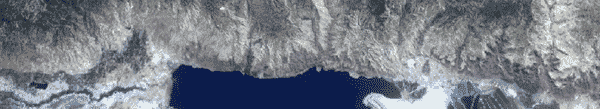
The Dead Sea is the terminal lake of the Jordan Rift Valley. It
is the lowest point on the surface of the earth, and the waters
have the highest density and salinity of any sea in the world.
The east and west shores of the Dead Sea are bounded by towering
fault escarpments that form part of the African-Syrian rift
system. The valley slopes gently upward to the north along the
Jordan River, and to the south along the Wadi Araba.
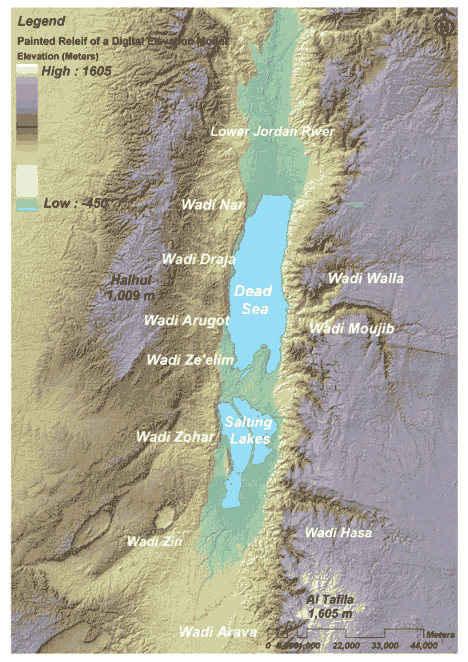
Map 1. Topography of the Dead Sea Basin
The Dead Sea
extends from 35o30’00 to 35o34’05 East and 30o58’01 to 31o46’01
North. Its total area is 634 km2, while its perimeter
is approximately 148 km . It lies some 1,357 feet (418 meters)
below sea level-the lowest elevation and the lowest body of
water on the surface of the Earth. The total surface area
of the Dead Sea catchment is approximately 40,700 km2.
The major Wadis in the Dead Sea catchment are Wadi Mujib, Wadi
Wala, Wadi Hasa, Wadi Draja, Wadi Arugot, Wadi Ze'elim, Wadi
Zohar, Wadi Zin and Wadi Arava (see Map 1). The elevation
ranges from 418 below sea level to 1,605 m (The mean elevation
is approximately 440 m above sea level), and slopes range from 0
to 87 degrees (65% of the study area has a slope of less than 10
degrees). The coastal areas of the Dead Sea Basin exhibit
complex relief characteristics with steep slopes. The highest
point, the highlands around Al Tafila (1,605 m), lies near the
South-eastern side of the basin.
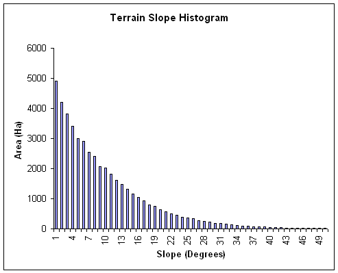
Figure 1: Terrain
Slope Histogram of the Dead Sea Basin
 Top Top
Surface Geology and Soil
Approximately, 28% of the study area is
composed of Coniacian-Camparian and Camparian Chalk and Chert
formations, 27% is composed of Turonian and Cenomanian
limestone, marl and dolostone formations while 16% is composed
of Sandstone, siltstone, dolostone and limestone formations.
Dolostone, clay, sand loess and gravel make up the remaining 29%
(Map 2).
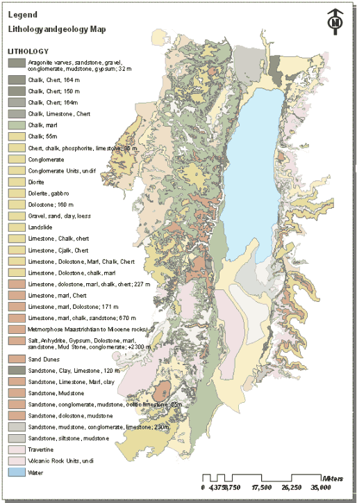
Map 2. Lithology Map of the Dead Sea Basin
The soil
depth varies widely depending on surface geology, relief and
vegetation density. The soil types in the study area include
Brown Lithosols and loessial Arid Brown Soils, Dark Brown Soils,
Brown Randzinas and Pale Randzinas, Terra Rossa, Bare Rocks and
Desert Lithosols, Brown Lithosols and Loessial Serozems.
Top
Climate
The climate of the
study area is highly variable. Average annual precipitation
decreases along two geographical gradients; namely the
latitudinal gradient as rainfall decreases from north to south
and the altitudinal gradient as rainfall decreases along with
the decrease in elevation. The maximum average annual
rainfall of 594 mm/yr occurs in the north-western part of the
study area (East Jerusalem) and the minimum average annual
rainfall of 80 mm/yr occurs along a small hyper-arid
longitudinal zone running along the Dead Sea coast. The mean
annual precipitation in the study area is approximately 200
mm/yr (Map 3), of which approximately 60% falls in the three
months of December, January and February (Figure 2).
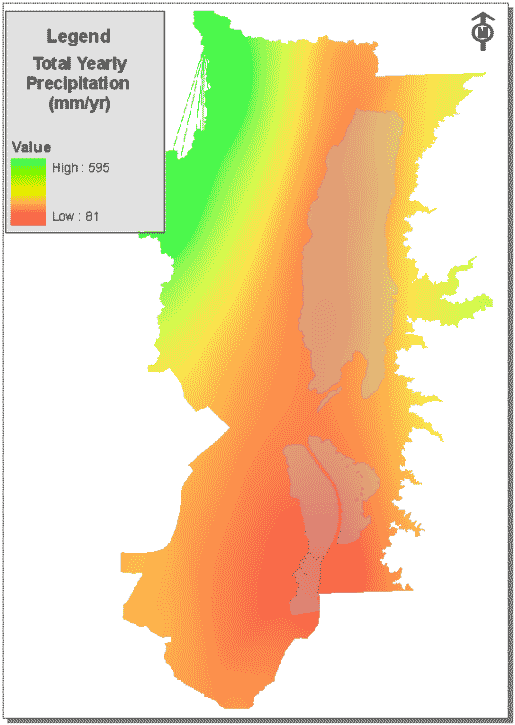
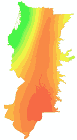
Map 3. Average Annual Precipitation in the study area
Top
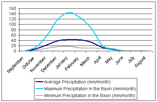
Figure 2.
Monthly precipitation distribution in the study area showing
precipitation patterns in the wet and dry areas of the Basin.
Temperatures vary from
an annual average of 17 degree centigrade in the Western side of
the Basin to 24 degrees centigrade along the Salting lakes
coastal area. In the western part of the study area, the dry hot
season (xerothermic period) starts in April and lasts for 6-7
months up to mid October whereas in the arid eastern part of the
study area the dry hot season lasts for 10-11 months from
February to mid November.
Based on the
above, the combination of hot, dry summers and wet winters
satisfy the conditions required to classify the climate of the
Dead Sea Basin as a Mediterranean climate.
Furthermore, the Emberger
(1971) method was used to define the subclasses of the
Mediterranean bioclimate of the Dead Sea Basin. It was found to
range from temperate and sub-humid (Al A’rrub Weather Station
Readings) to hot and desert (Jericho Weather Station Readings).
Potential evaporation (pan evaporation) in the study area varies
from 1,700 mm/year in the north-western part to 2,300 mm/year in
the northern Arava valley. Figure 3 shows the monthly values of
potential evapotranspiration in the Dead Sea Basin.
Average potential evaporation over the Dead Sea is approximately
1,980 mm/yr whereas average potential evaporation over the
salting lakes is approximately 2260 mm/yr. Actual
evaporation from the surface of the Dead Sea ranges
between 1,300-1,600 mm/yr and depends on several climatic
variable (e.g. wind speed, relative humidity, temperature) and
surface water temperature and water salinity.
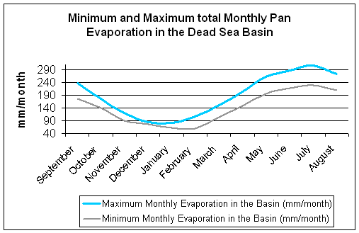
Figure 3. Minimum and Maximum observed values of total monthly pan
evaporation in different areas in the Dead Sea Basin
Top
|