Project Structure
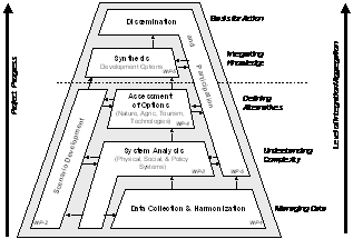
The project activities have been broken down into seven Working Packages (WP’s), six of which are operational and one (WP-7) is for the coordination (figure 1).
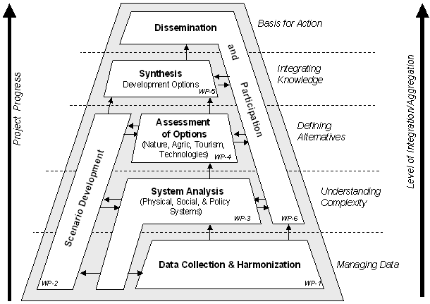
Figure 1: Project Structure. The project builds upon existing data (bottom) which will be synthesized to derive new knowledge about the systemic interconnections of the physical, the economic and the social system, and its inherent dynamics. The outcome (top) will be information that provides options for a more sustainable water management in the Dead Sea Basin. Note: For better clarity this figure refers to operational Working Packages (WP’s) only; it does not include WP-7 (Project Coordination).
The following is a brief description of the project work-packages (WPs):
WP-1 Data Collection & Harmonization:
In these three tasks, the regional partners will collect spatial and statistical data from available archives, maps, publications and from authorities. Data from the regional partners will be brought together to produce one harmonized output that will form the basis for assessment and modeling. Data will include:
· Topographic, geographic and biological data (incl. Historic/actual/projected land use)
· Socio-economic conditions and their changes (population density, households, tourism facilities, industry, growth potentials, and agriculture, master plans, etc…)
· Water resources (hydrogeology of the area, surface waters, groundwater aquifers, climate conditions); available water supply (quantities and qualities) from springs, wells, and surface water
· Water demand (& its changes); type of water use (quantities and qualities) in major categories of users (agriculture, households, public, industry, tourism, and nature
· Wastewater availability and reuse options
WP-2: Scenario Development:
WP-2.1 Criteria & Indicators for Scenarios
The criteria and indicators that are necessary for quantifying and Parameterizing scenarios will be defined. These parameters will describe the physical and social dimensions of development. It is particularly important to develop socio-economic indicators to describe the social dimension. This will also include the “value” of the Dead Sea to different stakeholders. Synergistic or antagonistic properties will be identified. Elements of change will also include factors that occur outside the study region but which will influence the water availability and quality.
WP-2.2 Scenario Management Tool
A computer tool based on PC Visual Basic programming will be developed that allows the definition and management of development scenarios. The tools will allow to translate overall aggregate development trajectories (e.g. “green tourism”, “more water imports”) into concrete scenarios with the appropriate parameters. The design of the tool will be harmonized with the requirements of system analysis (WP-3), so that the scenarios can be based on a systemic view.
WP-2.3 Realistic Scenario Synthesis
The project team will together define a set of realistic (yet alternative) development scenarios that will be used for the synthesis (WP-5). The scenarios will be closely documented through the associated scenario parameters developed in WP-2.1. These “realistic” scenarios will be discussed with the regional development authorities and communities. One of the scenarios will reflect “current/no major changes” situation, at least two scenarios will refer to situations that are compatible with a “more sustainable” water management. All of the scenario will be based on the (optimistic) assumption of regional peace agreements within the next 5 years.
WP-3: System Analysis
WP-3.1 Physical Subsystem
Using the collected data, the physical dimension of water supply and use (plus driving forces) and the consequences on the environment (particularly nature, land/soil, and groundwater) will be synthesized. The system analysis will also include water networks, sanitary networks, and water resources development projects. The analysis will also address the regional dimensions of the supply-use chain, and the exchange of water between the Dead Sea Basin and the region outside the basin.
WP-3.2 Social/economic Subsystem
The analysis will cover the social and economic issues of water use in a systemic approach, including the historical dimension. Issues that will be addressed include gender powers, traditions, health, perceptions, rights, equity, the role of communities, employment, benefits, income generation/distribution. This work also includes empiric data collection. It will also address the role that “values” plays for social system.
WP-3.3 Water Policy Analysis
System analysis will include policies on national and regional levels, including institutional aspects of water policy. It will also address the issue of driving forces for policy changes. Other issues that will be included are: traditional water rights, water policies in IL, JO, PS, players, role and power of stakeholders, international dimension, conflicts of interest. The system aspect that will be considered is the connection between policies (regional, communal, local) and the driving forces for them, particularly the role of economic factors, of NGO interest groups, and of communities.
WP-3.4 System Integration
The analyses will be integrated in a conceptual system model that is based on an appropriate spatial framework. The base data will be synthesized in spreadsheets; the integration model will be based on Visual Basic and on Vensim. The spatial dimension of the integration will be considered through predefined spatial units. The analysis will also identify and parameterize the driving forces and constraints for system changes. The output will allow to understand the current water management system in the Dead Sea Basin, and the effects of system changes on the viability of the basin. The most crucial issue is the linkage between social, economic and physical data. The approach to solve this is the translation of “data” into parameterized “influences” that can then be combined.
WP-4: Assessment of Options
WP-4.1 Essential Needs of Nature
The role of nature as a legitimate water user of its own right will be re-assessed. Using monitoring data from the present and the past, the ecological deterioration will be identified and quantified. The biophysical and social factors related to land degradation will be identified. The analysis will put particular emphasis on land use change processes that influence ecosystems, diverted water flows from the Upper Jordan River Basin and the contributory watersheds and the overexploitation of natural goods. Work will then focus on determining the essential (minimum) water that nature requires to preserve key processes. Water will be needed to preserve vulnerable ecotones, corridors between biomes, natural vegetation at biodiversity hot spots and rangelands (semi-natural areas). The latter is necessary to reduce the anthropogenic pressure on natural areas. The quantity of water required for natural and semi-natural areas will be determined using biophysical models.
WP-4.2 Alternatives for Irrigated Agriculture
Irrigation is a major water user with a very low water efficiency (income generation per unit of water consumed). Work will address on a general level the social and economic role of irrigated agriculture in arid areas, and options for changes. Specifically for the Dead Sea basin, the regional situation of agriculture will be analyzed: agriculture is one the one hand a major water user, but on the other hand is also a major victim of water shortage. Can agricultural practices be optimized to reduce water use, and to improve ecological quality? Are there alternatives for agricultural land use? What is the impact of agricultural policies (water price subsidies, globalization, national food security goals) on agricultural system? What is the role of agriculture for the social and economic fabric?
WP-4.3 Sustainable Tourism
Work will address the role and impact of tourism for society, economy and nature. The Jericho Oasis Casino complex (PL), the Ain Bokeq resort (IL) and the new Movenpick compound (JO) will serve as case studies for the current tourism system. Requirements for sustainable tourism will be described and applied to serve as a guideline for a more sustainable tourism planning in the region.
WP-4.4 New Technological Options
Work will address the impacts of using advanced technologies for water management in agriculture, public/municipal, tourism, and industry. Options that will be analyzed include the Red-Dead and Med-Dead projects, solar powered desalination, wastewater treatment and re-use, artificial groundwater recharge, water loss reduction, and unconventional sources. It will address the role of new technologies for reducing water losses, for reducing water consumption, for reusing and recycling water, and for mobilizing new or alternative water resources.
WP-5: Synthesis
WP-5.1 Dynamic Synthesis Model
The dynamic synthesis model will bring together the system integration model (WP-3.4) and the results from the scenario synthesis (WP-2.3). The dynamic model will be made with a system dynamic modeling tools, such as “Vensim”, and it will be linked with a GIS (ArcGIS). The model will allow to project the parameters that influence the water management system and the overall system behavior, following the assumptions for future development.
WP-5.2 Joint Synthesis Report
All project partners will contribute to this joint synthesis with the lead of partner UNEW. It will discuss and cover all knowledge that has been built up in the project, and apply the knowledge to development scenarios, one of them a “current/no major changes” development and at least two of them targeting a “more sustainable development” direction. The report will also include the advice and inputs from the users that are in the advisory groups (see WP-6.2). An annex to the final report will also “translate” the results into a format that fits the needs of decisions makers.
|